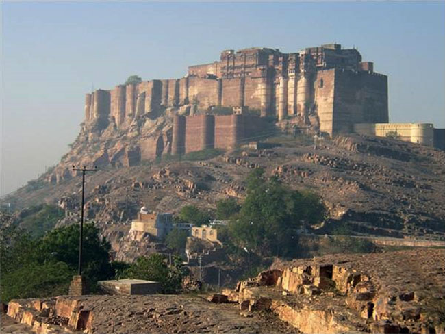
 NAHARGARH FORT The Indian state of Rajasthan is famous for its royal heritage. Formed by the union of many princely states ruled mainly by Rajputs, Rajasthan has many forts and palaces. Some of these palaces and forts are associated with important historical events as well. Nahargarh Fort, along with other two forts viz., Amer Fort and Jaigarh Fort, once formed a strong defense for Jaipur city. Built by Maharaja Sawai Jai Singh II in 1734, this fort was originally named Sudarshangarh Fort. Later, it was given a new name, Nahargarh which means 'abode of tigers'. Located in one of the oldest mountain ranges of the world, the Aravalli Hills, this fort gives you a breathtaking view of the scenic surroundings. One of the major tourist attractions of Jaipur, Nahargarh Fort is noted for its extended wall which connects it to the Jaigarh Fort. History Of The Fort Nahargarh Fort was built in 1734 by Maharaja Sawai Jai Singh II, founder of Jaipur, on the Aravalli hills, as a retreat place. Nahargarh Fort is connected to the Jaigarh Fort through its fortifications. It is believed that the construction of this fort was obstructed by the spirit of a Rathore prince, Nahar Singh Bhomia. However, the spirit was pacified when a temple dedicated to him was built inside the fort. Sawai Ram Singh renovated this fort in 1868. Architectural Layout Of The Fort The fort follows Indo-European architecture and there are many structures inside the fort. To the left of the entrance gate 'Tadigate', there is a temple dedicated to the deity of Jaipur rulers. Apart from this, there is another temple inside the fort, dedicated to the Rathore prince, Nahar Singh Bhomia. Another attraction in the fort is the 'Madhavendra Bhawan' built by Sawai Madho Singh. This is a two-storey building which has suites for the king and his twelve queens. It is divided into nine similar apartments and each of these apartments has a lobby, bedrooms, toilets, kitchen and store. Other structures inside the palace include Diwan-I-Aam, an open air enclosure where the king met the common men and listened to their problems and complaints. Important Battles Nahargarh Fort was never attacked but, it witnessed some major historical events, like the treaties with the Maratha forces which attacked Jaipur in the 18th century. This fort gave shelter to many Europeans in this region, including the British Resident's wife, during the Sepoy Mutiny of 1857. Nearby Tourist Attractions Located 2.7km away from the fort, Jantar Mantar is one of the five astronomical observatories in western central India. Other places worth visiting nearby are the City Palace, Hawa Mahal, Jalmahal, Jaigarh Fort and Amer Fort. Located in a scenic backdrop of the Aravalli Hills, Nahargarh Fort offers a breathtaking view of the hilly milieu. The wonderful trek from the foot of the hill to the top, where the fort is located, is truly a great experience. 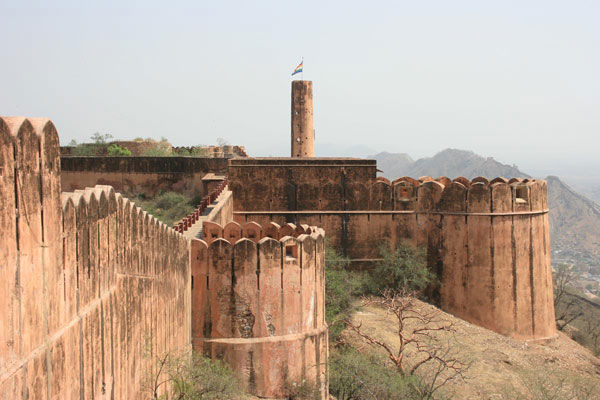
1 Comment
 Ladakh ("land of high passes") is a region of India in the state of Jammu and Kashmir that currently extends from the Kuen Lun mountain range to the main Great Himalayas to the south, inhabited by people of Indo-Aryan and Tibetan descent. It is one of the most sparsely populated regions in Jammu and Kashmir and its culture and history are closely related to that of Tibet. Historically, the region included the Baltistan (Baltiyul) valleys (now mostly in Pakistani Kashmir), the entire upper Indus Valley, the remote Zanskar, Lahaul and Spiti to the south, much of Ngari including the Rudok region and Guge in the east, Aksai Chin in the northeast (extending to the Kun Lun Mountains), and the Nubra Valley to the north over Khardong La in the Ladakh Range. Contemporary Ladakh borders Tibet to the east, the Lahaul and Spiti regions to the south, the Vale of Kashmir, Jammu and Baltiyul regions to the west, and the southwest corner of Xinjiang across the Karakoram Pass in the far north. Ladakh is renowned for its remote mountain beauty and culture. Aksai Chin is one of the disputed border areas between China and India. It is administered by China as part of Hotan County but is also claimed by India as a part of the Ladakh region of the state of Jammu and Kashmir. In 1962 China and India fought a brief war over Aksai Chin and Arunachal Pradesh, but in 1993 and 1996 the two countries signed agreements to respect the Line of Actual Control. In the past Ladakh gained importance from its strategic location at the crossroads of important trade routes,but since the Chinese authorities closed the borders with Tibet and Central Asia in the 1960s, international trade has dwindled except for tourism. Since 1974, the Government of India has successfully encouraged tourism in Ladakh. Since Ladakh is a part of strategically important Jammu and Kashmir, the Indian military maintains a strong presence in the region. History of Ladakh The Territorial Extent of Ladakh during the period of King Nyimagon about 975 A. D.-1000 A.D. as depicted in A History of Western Tibet by A.H. Francke, 1907 The 9 Stupas at Thiksey Monastery The empire of King Tsewang Rnam Rgyal 1., and that of King Jamyang Rnam Rgyal., about 1560 and 1600 A.D Phyang Gompa, Ladakh, India Hemis Monastery in the 1870s Rock carvings found in many parts of Ladakh indicate that the area has been inhabited from Neolithic times. Ladakh's earliest inhabitants consisted of a mixed Indo-Aryan population of Mons and Dards, who find mention in the works of Herodotus, Nearchus, Megasthenes, Pliny, Ptolemy, and the geographical lists of the Puranas. Around the 1st century, Ladakh was a part of the Kushana empire. Buddhism spread into western Ladakh from Kashmir in the 2nd century when much of eastern Ladakh and western Tibet was still practising the Bon religion. The 7th century Buddhist traveler Xuanzang describes the region in his accounts. In the 8th century, Ladakh was involved in the clash between Tibetan expansion pressing from the East and Chinese influence exerted from Central Asia through the passes. Suzerainty over Ladakh frequently changed hands between China and Tibet. In 842 Nyima-Gon, a Tibetan royal representative annexed Ladakh for himself after the break-up of the Tibetan empire, and founded a separate Ladakhi dynasty. During this period Ladakh acquired a predominantly Tibetan population. The dynasty spearheaded the second spreading of Buddhism, importing religious ideas from north-west India, particularly from Kashmir. The first spreading of Buddhism was the one in Tibet proper. Geography of Ladakh The Ladakh region has high altitude. Map of the central Ladakh region Landscape in Ladakh Ladakh is the highest plateau of state of Kashmir with much of it being over 3,000 m (9,800 ft). It extends from the Himalayan to the Kunlun Ranges and includes the upper Indus River valley. Historically, the region included the Baltistan (Baltiyul) valleys (now mostly in Pakistani Kashmir), the entire upper Indus Valley, the remote Zanskar, Lahaul and Spiti to the south, much of Ngari including the Rudok region and Guge in the east, Aksai Chin in the northeast, and the Nubra Valley to the north over Khardong La in the Ladakh Range. Contemporary Ladakh borders Tibet to the east, the Lahaul and Spiti regions to the south, the Vale of Kashmir, Jammu and Baltiyul regions to the west, and the southwest corner of Xinjiang across the Karakoram Pass in the far north. The historic but imprecise divide between Ladakh and the Tibetan Plateau commences in the north in the intricate maze of ridges east of Rudok including Aling Kangri and Mavang Kangri, and continues southeastward toward northwestern Nepal. Before partition, Baltistan, now under Pakistani control, was a district in Ladakh. Skardo was the winter capital of Ladakh while Leh was the summer capital. SOME PICS OF LEH |
Archives
June 2017
AuthorWe are tour consolidator who gives the best tour with best price and best facilities. 
Categories |


 RSS Feed
